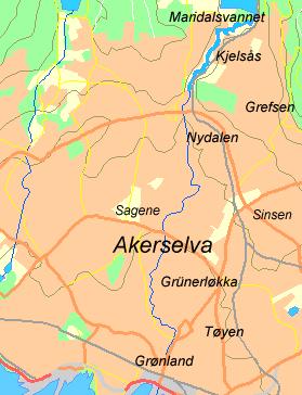
 Akerselva (Aker River) runs north, south through the centre of Oslo, a distance of 8 kilometres from its source at Maridalsvannet to Oslo harbour. It is flanked for almost the whole length by an excellent paved pathway that passes through the heart of what was Oslo’s industrial heritage but what is now a mixture of parkland and a major renovation area. The river tumbles steeply in parts, a feature which was utilised as a source of power by the many mills, workshops and factories that once flanked the river valley. Attracted by the abundant supply of water for power, industrialisation of the area began around 1850. The population grew rapidly from less than 30,000 to nearer a quarter of a million in less than 50 years. One of the first factories to be established was the Glads paper mill in the Sagene area of the city. It is believed the first mill to be powered by the river was established in the 13th century. There were many thriving saw mills operating in the 1700’s. The word Sagene is plural for word “saw”.
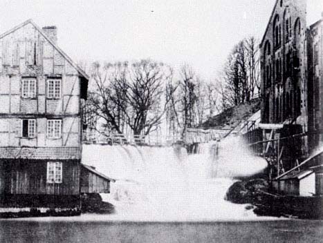 Factories, mills and workshops together with the accommodation to house the workers extended the length of the river. Many of the buildings have long been demolished. Fortunately, some of the grand old industrial buildings have been rescued and preserved. Buildings have been converted for a wide variety of purposes, including trendy designer apartments, IT businesses, design studios, restaurants, cafes, nightclubs and a variety of other businesses large and small.
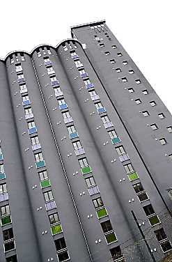 The Oslo students union undertook one of the most enterprising rescue projects. They acquired a non-descript concrete grain silo on the banks of the river and converted it into student accommodation. It is now a much-admired local landmark. There is currently a project underway to convert the massive Ringers Brewery into upmarket lofts and apartments.
The workers that flooded into the area were accommodated in a wide range of housing including the traditional wooded cottages and houses many of which date back to the 1700’s. Whilst many of these have long since disappeared examples of traditional buildings can be found scattered among the more modern accommodation. There are a few areas such as Maridalsveien and Sandakerveien where there are carefully preserved streets of these traditional houses. In Kampen a whole district of these attractive shiplap covered houses in their various neutral hues, has been preserved. The traditional housing gave way to more substantial brick and concrete dwellings as the population exploded. A typical example of the type of accommodation common in the area can be seen where we have our apartment. A quadrangle of 3 story apartments built around a communal garden area. Apparently when they were built they were almost self sufficient for amenities with communal laundry, kitchen, vegetable gardens etc. It is hard to imagine looking at the place today that when they where built as many as 10 people shared a small room.
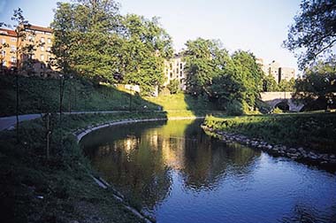
In addition to the natural and spectacular waterfalls on the river there is evidence of mans intervention with weirs, sluices, mill ponds and other artefacts along the route all of which add to the interest of what is a spectacular and very interesting walk. During the winter months, the weirs and waterfalls freeze to form spectacular ice sculptures and cascades. Parts of the river are suitable for swimming and water sports. Canoe hire is popular in the and less turbulent, lower reaches. To sustain the weary walker there is a scattering of interesting cafes and bars along the way.
No comments:
Post a Comment